maskRangeR is an R package that refines species distribution models (SDMs) to improve estimates of species’ current ranges in several ways: spatiotemporally matching in-situ observations of species’ occurrence with environmental and/or remotely sensed data (e.g., MODIS-derived) to assess tolerances; directly incorporating expert knowledge of sp ...
DOI: 10.21425/F5FBG53589
Last Update: 2022
Data analysis Species populations Terrestrial Marine Freshwater Birds Mammals Fishes Reptiles Amphibians Butterflies Macroinvertebrates Other Invertebrates
Login to add the tool into your favorites.
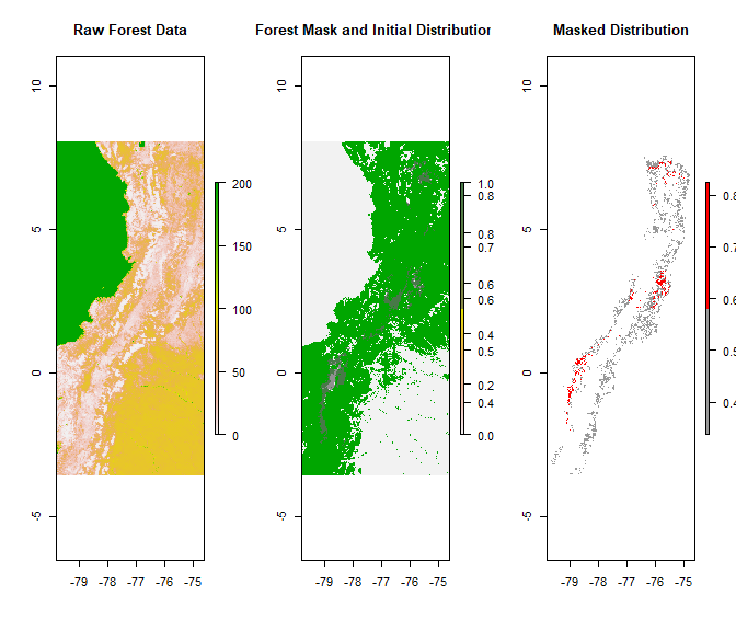
maskRangeR is an R package that refines species distribution models (SDMs) to improve estimates of species’ current ranges in several ways: spatiotemporally matching in-situ observations of species’ occurrence with environmental and/or remotely sensed data (e.g., MODIS-derived) to assess tolerances; directly incorporating expert knowledge of species’ ranges; sequential masking of driving environmental variable tolerances; accounting for competitive interactions.
Monitoring program(s) or initiative(s) using the tool:
Colombia BON
| Contact person: | Mary Blair |
|---|---|
| Contact e-mail: | mblair1@amnh.org |
| Contact Organization: | American Museum of Natural History |
| License: | No license assigned |
| Technical Status: | Finish and with constant technical support |
| Recommendation for its use: | Estimates of species’ ranges can inform many aspects of biodiversity research and conservation-management decisions. Many practical applications need high-precision range estimates that are sufficiently reliable to use as input data in downstream applications. One solution has involved expert-generated maps that reflect on-the-ground field information and implicitly capture various processes that may limit a species’ geographic distribution. However, expert maps are often subjective and rarely reproducible. In contrast, species distribution models (SDMs) typically have finer resolution and are reproducible because of explicit links to data. Yet, SDMs can have higher uncertainty when data are sparse, which is an issue for most species. Also, SDMs often capture only a subset of the factors that determine species distributions (e.g., climate) and hence can require significant post-processing to better estimate species’ current realized distributions. To address this, expert knowledge, diverse data types, and SDMs can be used together in a transparent and reproducible modeling workflow. maskRangeR provides tools to show how expert knowledge regarding species’ habitat use, elevation, biotic interactions, and environmental tolerances can be used to make and refine range estimates using SDMs and various data sources, including high-resolution remotely sensed products. This range-refinement approach is primed to use various data sources, including many with continuously improving spatial or temporal resolution. Refined range maps can be considered as improved representations of a species’ realized distribution, aiding in conservation decision-making. |
| URL(s): |
https://github.com/wallaceEcoMod/maskRangeR
https://wallaceecomod.github.io/maskRangeR/maskRangeR_Tutorial.html |
Login to add a review for the tool maskRangeR
TOOLS YOU MAY ALSO LIKE